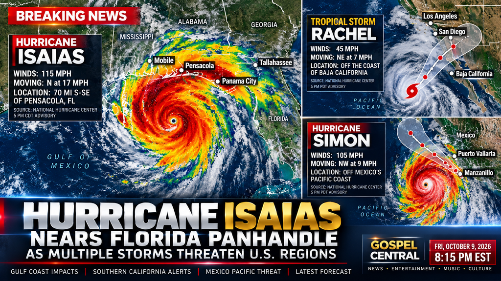
Hurricane Isaias is approaching the northern Gulf Coast, while Tropical Storm Rachel raises concerns for Southern California. Hurricane Simon is also strengthening near Mexico’s Pacific coast.
Several regions across the United States and Mexico are preparing for potentially dangerous weather as three tropical systems develop across the Atlantic and Pacific basins.
According to the National Hurricane Center, Hurricane Isaias is approaching Florida’s Panhandle, Tropical Storm Rachel could bring flooding and coastal impacts to Southern California, and Hurricane Simon is forecast to strengthen before approaching Mexico’s Pacific coast.
Hurricane Isaias Targets Florida’s Panhandle
According to the . 5 p.m. CDT update Friday, Hurricane Isaias had maximum sustained winds of 115 mph and was moving north at 17 mph. Its center was approximately 70 miles south-southeast of Pensacola, Florida.
The storm threatens the Florida Panhandle and nearby parts of Alabama with damaging winds, dangerous storm surge and heavy rainfall. Conditions could deteriorate rapidly as the hurricane approaches land.
Major cities and areas to watch
● Pensacola, Florida: Near the storm’s projected approach, with dangerous winds, coastal flooding and storm surge possible.
● Mobile, Alabama: At risk of strong winds, heavy rain and coastal flooding.
● Tallahassee, Florida: Could experience heavy rainfall and additional hazards as the storm moves inland.
● Panama City, Florida: Residents should monitor local warnings for damaging winds, rain and coastal impacts.
● New Orleans and Baton Rouge, Louisiana: Potential rain and wind impacts depend on the storm’s track and evolution.
● Jackson, Mississippi: Heavy rain and possible flooding could develop as the system moves inland.
● Birmingham, Alabama: Strong winds and rainfall are possible as the storm progresses inland.
● Atlanta, Georgia: Heavy rain and flooding could affect parts of the region as the system moves northeast.
These cities are not all expected to experience a direct hurricane strike. The National Hurricane Center provides localized forecast information for these areas, and residents should follow their local National Weather Service offices for specific warnings.
Even after landfall, Isaias could produce dangerous conditions as rainfall spreads inland across the Southeast and potentially into parts of the Midwest and Northeast through Monday.
Tropical Storm Rachel Raises Concerns for Southern California
Tropical Storm Rachel is also drawing attention after prompting tropical storm warnings for portions of western Baja California and a tropical storm watch for San Diego County.
The National Hurricane Center reported Friday afternoon that Rachel had maximum sustained winds of 45 mph and was moving northeast. Its forecast track raises concerns about rainfall, strong wind gusts, hazardous surf and coastal flooding in parts of Southern California.
Cities and areas to monitor
● San Diego, California: Coastal flooding, dangerous surf and heavy rainfall are among the primary concerns.
●Los Angeles, California: High tides and coastal flooding could affect vulnerable shoreline communities.
● Newport Beach, California: Coastal flooding has already been reported, with additional impacts possible.
● Long Beach, California: Coastal areas could experience additional flooding and hazardous surf.
● Las Vegas, Nevada: Forecast rainfall could contribute to localized flooding as Rachel’s remnants move inland.
The exact extent of the impacts will depend on Rachel’s track and interaction with other weather systems. Residents should monitor local forecasts rather than assume every city will experience the same conditions.
Hurricane Simon Strengthens Near Mexico
Meanwhile, Hurricane Simon is strengthening over the eastern Pacific and threatens Mexico’s southwestern and west-central coastline.
The National Hurricane Center reported Friday afternoon that Simon had maximum sustained winds of 105 mph, with additional strengthening expected. Forecasts indicated the storm could become a major hurricane as it approaches Mexico’s Pacific coast.
The areas facing particular concern include coastal communities near Manzanillo and Puerto Vallarta, where dangerous winds, heavy rainfall, flooding and mudslides could affect residents and visitors.
Simon is not currently forecast to make landfall in the continental United States. However, its development remains important to the broader regional weather outlook.
What Residents Should Do Now
People in potentially affected areas should take the following precautions:
● Monitor local weather alerts and updated storm forecasts.
● Follow evacuation instructions issued by local emergency officials.
● Prepare for possible power outages and interruptions to travel.
● Avoid beaches and coastal areas experiencing dangerous surf or flooding.
● Never drive through flooded roads.
Storm tracks, warnings and expected impacts can change quickly. Residents should rely on official forecasts for their specific locations rather than broad regional predictions.
For the latest storm positions, forecast tracks, watches and warnings, visit the National Hurricane Center.
About the Author